
Singapore, officially the Republic of Singapore, is an island country off the southern tip of the Malay Peninsula, 137 kilometres (85 mi) north of the equator, south of the Malaysian state of Johor and north of Indonesia's Riau Islands.
Note[]
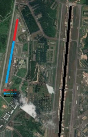
For those who don't understand the runways of Tengah air base, Here is a image of the runways
List[]
| Civillian airports | ||||
|---|---|---|---|---|
|
Airport |
Coordinates |
Runway |
Length |
Elevation |
| Changi International Airport | 01°21′33″N | 02L / 20R | 4'000m
13'123ft |
6m
22ft |
| 02C / 20C | ||||
| 02R / 20L
(Air base) | ||||
| Seletar Airport
WSSL / XSP |
01°25′01″N | 03 / 21 | 1'840m
6'023 |
11m
36ft |
|
Military air bases | ||||
|---|---|---|---|---|
| Airport | Coordinates | Runway | Length | Elevation |
| Changi Air Base (East)
WSAC |
1 20'18''N | 02 / 20 | 4'000m
13'123ft |
1m
3ft |
| Paya Lebar Air Base
WSAP / QPG |
1°21'27.6"N | 02 / 20 | 3'780m
12'401ft |
20m
65ft |
| Sembawang Air Base
WSAG |
01°25′31″N | 04 / 22 | 1'907m
6'255ft |
26m
86ft |
| 05 / 23 | 1'036m
3'400ft | |||
| Tengah Air Base
WSAT / TGA |
01°23′14″N | 18 / 36 | 2'743m
8'999ft |
15m
50ft |
| 18 / 36 | 352m
1'155ft | |||
| 01 / 19 | 688m
2'258ft | |||
| Military Airstrips | ||||
|---|---|---|---|---|
| Airport | Coordinates | Runways | Length | Elevation |
| Pulau Sudong Airstrip | 01°12′19″N | 09 / 27 | 2'440m
7'999ft |
7m
22ft |
|
Former Airports | ||||
|---|---|---|---|---|
| Airport | Coordinates | Runways | Length | Elevation |
| Kallang Airport | 01 18'26''N103 52'24''E | 06 / 24 | 1'677m
5'501ft |
5m
16ft |
See Also[]
List of airports by ICAO code: W
List of heliports in Singapore